Projects
CURRENT PROJECTS
*Modern *Experiments *Ancient
RioMAR consortium
![]() *** RioMAR Consortium is a co-operative CSM-UT Austin industrial multi-disciplinary research program on source to sink sediment transport and facies tracts that links ancient, modern and experimental datasets. Look below for the logo to see which projects are linked to RioMAR.
*** RioMAR Consortium is a co-operative CSM-UT Austin industrial multi-disciplinary research program on source to sink sediment transport and facies tracts that links ancient, modern and experimental datasets. Look below for the logo to see which projects are linked to RioMAR.
Global modern river discharge analyses
Quantitative analyses of global river discharge variability and hydrograph shape
Mark Hansford, Piret Plink-Bjorklund and Evan Jones
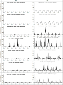 Discharge variability is a key control on rivers’ hydrological behavior, such as the frequency and magnitude of floods. A better understanding of discharge variability and how that variability is linked to global climate has implications for flood prediction, risk analyses and mitigation strategies. Furthermore, river discharge variability is a key control on river morphodynamics, and thus on river facies and architecture. Here we present a review of quantitative methods in river discharge variability analyses, and utilize the Global Runoff Data Centre’s global daily discharge database of 575 rivers to analyze global discharge variability patterns and compare those patterns to hydroclimate conditions. Our approach differs from previous attempts to link river discharge patterns to climate in that we define hydroclimate types that combine the Köppen-Geiger climate types with precipitation variability. We develop new quantitative criteria, and use a combination of multiple discharge variability criteria to compare hydrograph shapes to hydroclimate types. These analyses show that river discharge patterns fall into four statistically different and predictable groups as characterized by flood magnitude, hydrograph shape, and inter-annual variability in discharge. These four hydrological groups are: (1) persistent hydrology rivers, (2) single storm controlled variable discharge rivers, (3) rivers with seasonal hydrology, and (4) extreme and erratic hydrology rivers.
Discharge yields in modern rivers with variable hydrological regimes: Implications for scaling discharge and drainage basin size at different flow magnitudes
Evan Jones, Piret Plink-Bjorklund and Mark Hansford
 Key Points:
- Average discharge is a flow event of variable magnitude and frequency in modern rivers and is not a representative measure in variable discharge rivers
- At magnitudes of discharge higher than 99th percentile, runoff yields of rivers worldwide are statistically indistinguishable and most characteristic of the runoff capacity of a river’s drainage basin area across different climate zones and hydrologic regimes
- Predictive uncertainty in scaling relationships between a river’s catchment area and discharge is reduced at higher magnitudes of flow.
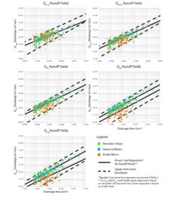
The size of the river’s catchment area is a first-order control on the amount of discharge routed through a river system. The state of discharge that is in geomorphic equilibrium with the channel that conveys it, the channel-forming discharge, is of variable magnitude and recurrence interval in rivers with catchments in different physiographic and climatic zones. Temporal variability of historical river discharge is strongly influenced by climatic forcing. A better understanding the amount of runoff that best characterizes a river’s catchment in both modern and ancient river systems requires a quantitative assessment of the influence of discharge variability on river dynamics. Our approach assesses discharge variability in modern rivers worldwide using daily gauging station measurements of flow rate. Here we show that while average discharge scales to catchment area in river systems with very persistent hydrology, in rivers with more variable hydrology this relationship is weak. Higher magnitude flow events have a strong correlation to catchment area across all hydrologic regimes. We conclude that flow events larger than 99th percentile, including flow events of a similar recurrence interval to bankfull flow, are the most characteristic of the runoff capacity of a river’s drainage basin area across different climate zones and hydrologic regimes. Data from the Global Runoff Data Centre’s global daily discharge database.
Variable discharge river sedimentary record
**Morphodynamics of rivers strongly affected by monsoon precipitation: Review of depositional style and forcing factors
Piret Plink-Bjorklund
 Rivers that receive significant amounts of their surface water supply from monsoon precipitation characteristically experience seasonal floods, and display seasonally highly variable discharge, controlled by the monsoon trough passage and its related cyclones. The intense summer rainfall causes high-magnitude floods, whereas rivers only transmit a low base flow during the dry winters. For many rivers in the sub-humid to arid subtropics, bordering the monsoon domain, the monsoon rain is also the main source of surface water recharge. However, such rivers may receive monsoon rain and transmit discharge only during abnormal or strengthened monsoon seasons. This annual discharge variability or range, as compared to the mean annual discharge, distinguishes the monsoonal and subtropical rivers from the rivers in equatorial tropics and temperate perennial precipitation zones, where the annual range is relatively small compared to the annual mean discharge. This review explores the effects of this seasonal and yearly variable rainfall, and the resultant highly peaked discharge pattern on river morphodynamics, and presents a comparison of modern and ancient monsoonal and subtropical river deposits. The field datasets and literature analyses discussed herein provide recognition criteria for monsoon-controlled river deposits, by documenting the diversity of the sedimentary facies, macroforms (bar forms), and architectural elements common in ancient and modern monsoon-controlled rivers. The review demonstrates that seasonal and inter-annual precipitation range is a key control on river morphodynamics, and resultant sedimentary facies characteristics, rather than the specific climate zone or average annual precipitation. (Plink-Bjorklund, 2015; 2018)
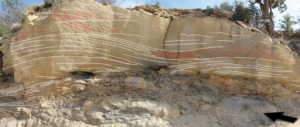
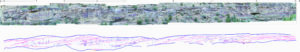
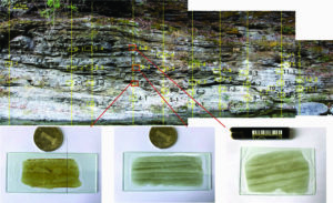
*Variable-discharge-river macroforms in the Sunnyside Delta Interval of the Eocene Green River Formation, Uinta Basin, US
Jianqiao Wang and Piret Plink-Bjorklund
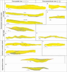 An outcrop dataset from the early Eocene Sunnyside Delta Interval of the Green River Formation in the Uinta Basin, Utah, USA documents alluvial channel lithosomes. The abundance of Froude supercritical-flow sedimentary structures, together with an abundance of high-deposition-rate sedimentary structures, in-channel bioturbation and pedogenic modification, in-channel muds and thick soft-clast conglomerates identify these lithosomes as deposits of variable-discharge rivers. These recognition criteria are part of an emerging facies model for variable-discharge rivers. This facies model, however, lacks recognition criteria for macro- or bar-scale stratal patterns of variable-discharge rivers. Here we present a dataset that corroborates some known stratal patterns and provides examples of hithertho unknown bar-scale stratal patterns of variable-discharge rivers, including: (1) low-angle downstream accretion sets that may form as washed-out sheets in high sediment supply conditions or downstream of hydraulic jumps; (2) steep upstream accretion sets that imply deposition from systematically upstream-migrating channel-scale hydraulic jumps (cyclic steps); (3) concave-up, upward-flattening steep downstream accretion sets that are consistent with aggradation in channel-scale hydraulic-jump scours; (4) upstream and lateral accretion sets that may be linked to high-magnitude flood reworking of point bars; and (5) aggradation or vertical accretion sets of ambiguous origin. We compare these unconventional stratal patterns to the established bar strata, such as those formed by point bars and braid bars and provide a discussion on formative conditions for the here documented unconventional strata. We highlight a need for further studies on the effect of discharge variability on bar formation and on the link between river morphology and bar types. (Wang and Plink-Bjorklund in review)
*Precipitation variability signature in the fluvial succession of the Paleogene San Juan Basin, New Mexico
Kristi Zellman, Piret Plink-Bjorklund and Henry Fricke
*Variable discharge river macroforms, Uinta Basin
Haipeng Li and Piret Plink-Bjorklund
Froude supercritical flow and deposits: experiments, river and deepwater records
*Froude supercritical flow processes and sedimentary structures: New insights from experiments with a wide range of grain sizes
Kenya Ono, Piret Plink-Björklund, Joris T. Eggenhuisen, and Matthieu J.B. Cartigny
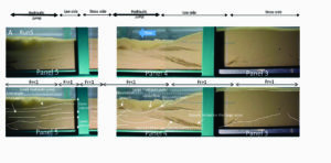 Recognition of Froude supercritical flow deposits in environments that range from rivers to the ocean floor has triggered a surge of interest in their flow processes, bedforms and sedimentary structures. Interpreting these supercritical flow deposits is especially important as they often represent the most powerful flows in the geological record. Insights from experiments are the key to reconstruct palaeo-flow processes from the sedimentary deposits. So far, all experimentally produced supercritical flow deposits are of a narrow grain size range with fine to medium sand, while deposits in the rock record often consist of a much wider grain-size distribution. This paper presents results of supercritical flow experiments with a grain-size distribution from clay to gravel. These experiments show that cyclic steps can produce more complex and a larger variety of laminations than the previously suggested backsets and scour-and-fill structures. Our experiments also produced irregular lenses, mounds and wedges with backsets and foresets, as well as undulating planar to low-angle upstream and downstream dipping laminae. The here presented experiments also demonstrate several additional controls on the sedimentary structures that have hitherto not been considered, such as the size and migration rate of the hydraulic jump and substrate cohesion. We further demonstrate that Froude supercritical flow promotes suspension transport of all grain sizes, including coarse sands and gravels. Surprisingly, we observed that all grain size were rapidly deposited just downstream of hydraulic jumps, including silt and clay. These results expand the range of dynamic mud deposition into supercritical flow conditions, where local transient energy reduction rather than overall flow waning conditions allow for deposition of fines. Comparison of the experimental deposits to outcrop datasets with a grain size range from conglomerates to mudstones, shows significant similarities and highlights the role of supercritical flow internal transient instabilities, rather than overall flow condition changes, in producing lithologically and geometrically complex stratigraphy. (Ono et al subm.)
*Froude supercritical flow bedforms in deepwater slope channels? Field examples in conglomerates, sandstones and fine-grained deposits
Kenya Ono and Piret Plink-Bjorklund
 Active margin continental slope outcrops from the Eocene Juncal Formation, the Eocene La Jolla Group and the Miocene Capistrano Formation display sedimentary structures and depositional geometries that suggest deposition from Froude supercritical flow, based on comparison to strata produced by flume experiments. These deposits range from boulder-size soft clasts and cobble-size hard clasts to silt and mud, and display long wavelength and low-amplitude convex-up and concave-up geometries that range from centimetre to hundreds of metres scale, low-angle foresets and backsets, and common internal and bounding erosion surfaces from centimetres to tens of metres in depth. In places, planar laminations, structureless beds and normally graded beds are laterally or vertically associated with such structures. In other places, consistent backsets or deep and steep-sided scours occur. This study aimed to discuss the origin of the observed bedforms, contributed to recognition of supercritical flow deposits on continental slopes and expanded the outcrop examples of supercritical flow deposits to silt and mud. This work implies that the erosive and powerful Froude supercritical flow turbidity currents may have a substantial impact on erosional and depositional dynamics on deepwater slopes, especially on active margins due to the steep gradients and high
sediment supply. (Ono and Plink-Bjorklund, 2018)
*Froude supercritical flow channels in submarine canyon complexes, La Jolla Group, southern California
Kenya Ono and Piret Plink-Bjorklund
 This paper documents an outcrop example of slope channel complexes from the La Jolla Group of the southern Californian Eocene forearc basin. This dataset demonstrates that the three slope channel complexes consist of channels 50-840 m wide and 5-100 m deep that display a relatively low aspect ratio, exhibiting an amalgamated and avulsive stacking pattern. Individual channels have a variety of heterolithic to sandstone and conglomerate fills, and all channel fills are dominated by Froude supercritical flow deposits. The transition of three channel complexes is considered to be related to the continental slope progradation on the upper slope. The potential progradational channel complexes demonstrate that highly channelized upper slope environment and the considerably lower slope progradation rate may be distinct characters of the active margins.
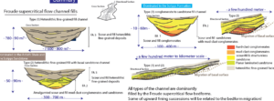
*OUTCROP EXAMPLE OF A CHANNELIZED SLOPE FAN, EOCENE JUNCAL FORMATION: ARCHITECTURE AND FROUDE SUPERCRITICAL FLOW CHANNEL FILL DYNAMICS
Kenya Ono and Piret Plink-Bjorklund
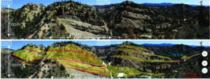 This paper documents an outcrop example of a channelized slope fan complex from the Juncal Formation of the southern Californian Eocene forearc basin. This dataset demonstrates that the slope fan consists of channels 360-860 m wide and 25-60 m deep that display a relatively high aspect ratio. The majority of the fan volume is formed by avulsive channel complexes. Individual channels have sandy to heterolithic, or just heterolithic, fills. Some channels are vertically stacked and composed of sandstone fills. All channel fills are dominated by Froude supercritical flow facies and geometries, and indicate frequent erosion and sediment bypass that alternated with rapid local deposition.
*Supercritical flow signatures and erosional features in Juncal Fm basin floor fans
Dessy W Sapardina and Piret Plink-Bjorklund
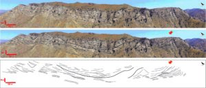 This drone photography survey of the Middle Eocene Juncal Formation in in Alyson Canyon in Los Padres National Forest, Santa Barbara and in Ojala, California, was motivated by a previous RioMAR study of approximately coeval slope succession in the Frazier Park area. Previous studies interpreted the Alyson Canyon area as proximal depositional lobe complexes in a basin-floor fan (Thompson, 1987), and the Ojala area along Highway 33 as outer-fan setting of depositional lobes (Obligado, 2003). In the Alyson Canyon area the facies are sandstone dominated and the sandstone facies occur as amalgamated, erosionally bound lenticular deposits. Only minor thinner-bedded and more tabular facies occur at the base of the outcrop. Sedimentary facies are dominated by scour and fill structures with upward flattening laminae, low-angle convex-up structures and backsets. The Ojai outcrops are also sandstone prone but the small size of the outcrop does not allow to observe larger bounding erosion surfaces. A few m to dm scale erosional scours are common and scour and fill structures and backsets are common sedimentary structures. In the Ojala area a proportion of heterolithic facies is larger and some heterolithic facies have a tabular architecture suggesting deposition in sheets or lobes, whereas sandstone-prone facies occur as erosionally bound lenticular deposits. Scour and fill structures and backsets are common sedimentary structures. Comparison to Froude supercritical flow experimentally produced data suggest that Froude supercritical flow deposits are common in the Juncal Formation basin floor fans. The erosion surfaces and the association of sandstone prone facies with the erosionally bound deposits suggest that the proportion of channelized deposits is high, and present even in outer-fan setting.
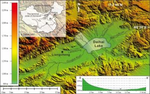
*Supercritical Flow records in a Modern River-delta System Strongly Affected by Monsoon Precipitation in Semi-arid Area, Daihai Lake, Northern China
Chengpeng Tan and Piret Plink-Bjorklund
 The first study that links modern supercritical flow river and delta deposits
*Cambian mudstones deposited from Froude supercritical flow, in Southwestern Micang Mountains of Northern Sichuan, China
Jijia Liao
**Morphodynamics of rivers strongly affected by monsoon precipitation: Review of depositional style and forcing factors
Piret Plink-Bjorklund
Rivers that receive significant amounts of their surface water supply from monsoon precipitation characteristically experience seasonal floods, and display seasonally highly variable discharge, controlled by the monsoon trough passage and its related cyclones. The intense summer rainfall causes high-magnitude floods, whereas rivers only transmit a low base flow during the dry winters. For many rivers in the sub-humid to arid subtropics, bordering the monsoon domain, the monsoon rain is also the main source of surface water recharge. However, such rivers may receive monsoon rain and transmit discharge only during abnormal or strengthened monsoon seasons. This annual discharge variability or range, as compared to the mean annual discharge, distinguishes the monsoonal and subtropical rivers from the rivers in equatorial tropics and temperate perennial precipitation zones, where the annual range is relatively small compared to the annual mean discharge. This review explores the effects of this seasonal and yearly variable rainfall, and the resultant highly peaked discharge pattern on river morphodynamics, and presents a comparison of modern and ancient monsoonal and subtropical river deposits. The field datasets and literature analyses discussed herein provide recognition criteria for monsoon-controlled river deposits, by documenting the diversity of the sedimentary facies, macroforms (bar forms), and architectural elements common in ancient and modern monsoon-controlled rivers. The review demonstrates that seasonal and inter-annual precipitation range is a key control on river morphodynamics, and resultant sedimentary facies characteristics, rather than the specific climate zone or average annual precipitation. (Plink-Bjorklund, 2015; 2018)
*Variable-discharge-river macroforms in the Sunnyside Delta Interval of the Eocene Green River Formation, Uinta Basin, US
Jianqiao Wang and Piret Plink-Bjorklund
An outcrop dataset from the early Eocene Sunnyside Delta Interval of the Green River Formation in the Uinta Basin, Utah, USA documents alluvial channel lithosomes. The abundance of Froude supercritical-flow sedimentary structures, together with an abundance of high-deposition-rate sedimentary structures, in-channel bioturbation and pedogenic modification, in-channel muds and thick soft-clast conglomerates identify these lithosomes as deposits of variable-discharge rivers. These recognition criteria are part of an emerging facies model for variable-discharge rivers. This facies model, however, lacks recognition criteria for macro- or bar-scale stratal patterns of variable-discharge rivers. Here we present a dataset that corroborates some known stratal patterns and provides examples of hithertho unknown bar-scale stratal patterns of variable-discharge rivers, including: (1) low-angle downstream accretion sets that may form as washed-out sheets in high sediment supply conditions or downstream of hydraulic jumps; (2) steep upstream accretion sets that imply deposition from systematically upstream-migrating channel-scale hydraulic jumps (cyclic steps); (3) concave-up, upward-flattening steep downstream accretion sets that are consistent with aggradation in channel-scale hydraulic-jump scours; (4) upstream and lateral accretion sets that may be linked to high-magnitude flood reworking of point bars; and (5) aggradation or vertical accretion sets of ambiguous origin. We compare these unconventional stratal patterns to the established bar strata, such as those formed by point bars and braid bars and provide a discussion on formative conditions for the here documented unconventional strata. We highlight a need for further studies on the effect of discharge variability on bar formation and on the link between river morphology and bar types. (Wang and Plink-Bjorklund in review)
*Precipitation variability signature in the fluvial succession of the Paleogene San Juan Basin, New Mexico
Kristi Zellman, Piret Plink-Bjorklund and Henry Fricke
*Variable discharge river macroforms, Uinta Basin
Haipeng Li and Piret Plink-Bjorklund
Floods and their link to river hydrology
Sustainable Flood Prediction and Mitigation
Piret Plink-Bjorklund
Why do floods pose a challenge?
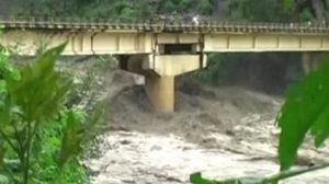
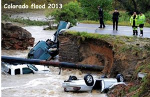 Floods pose a major impact on society by loss of life, livelihood, infrastructure, agricultural lands, and water quality. Many floods are driven by meteorological events and thus linked to hydroclimatic conditions, such as rainfall distribution and intensity. Consequences of extreme weather events are intensified due to population growth, economic growth, urbanization and landscape disturbance. Extreme weather also appears to be growing more frequent across the United States and globally, and it follows that frequency, severity and duration of hydro-meteorological hazards will also increase. Thus, it is more essential than ever that we have the capability to deliver effective flood prediction and mitigation strategies.
What is the problem with current prediction and mitigation strategies?
- From the start of flood mitigation guidelines (e.g. USWRC, 1967), our ability to predict and mitigate floods has relied on 100-year flood scaling. According to this approach, mitigation structures are designed to the height of the 100-year flood inundation levels. However, the predicted 100-year flood scale is most likely not linked to actual 100-year recurrence intervals, as demonstrated in recent years with numerous 100-1000-year scale events occurring within a few months (see also Naylor et al., 2017; and the new USGS guidelines in England et al., 2017).
- This inundation or water level height is considered as the sole defining flood hazard (Sinha, 2009; Syvitski and Brakenridge, 2013; England et al., 2017) in all rivers globally, independent on their hydrological behavior. Yet only in some rivers, where floods build gradually, is the inundation height really the defining flood hazard. In other rivers, floods build instantaneously in response to meteorological events with an extreme increase in discharge and in water power that causes erosion of sediment and erosional damage to infrastructure. Rivers with different hydrology pose different flood hazards (Hansford et al., in review). Despite significant differences in river flood behavior, flood mitigation is globally approached by barrage (levee) and dam construction. Yet for many rivers, there is no evidence for appreciable flood moderation with such structures (Sinha, 2009; Syvitski and Brakenridge, 2013). On the contrary, these engineering structures, developed for one class of rivers, are likely to push other rivers close to their discharge capacity threshold, and allow even moderate meteorological events to trigger catastrophic floods, such as occurred in 2008 in Bihar, India (Sinha, 2008).
- The lack of hydrograph shape analyses is currently one of the main shortcoming in river discharge and flood analyses (Hirsch, 2017). Another significant shortcoming in flood prediction is related to the knowledge gap on how rainfall patterns (such as intensity, duration, amplitude) link to flood hazards, and how they differ in rivers with different hydrology (Hansford et al., in review).
- Under changing climate, extreme whether events become more frequent and more extreme, but we are currently unable to estimate how this affects river floods, because our current analytical methods return high uncertainties in longer-term changes and future flood trends (Hirsch, 2018).
What is a potential solution?
 Develop a new river classification system based on river hydrograph shape, flood response and hydroclimatic drivers, to increase significantly the accuracy of flood prediction and effectiveness of flood mitigation. Using multiple data sources and data analysis methods, we can partition rivers globally into flood response types, and establish specific prediction, risk analyses and mitigation strategies and practices for each type. We can achieve this by developing new classifications for river behavior that account for flood response and a much more complete range of hydroclimatic drivers. These methods are not currently utilized, although prior pilot studies indicate their strength (Plink-Bjorklund, 2015; Davy et al., 2017; Joes, 2017; Hansford et al., in review). These methods can be applied to river discharge databases globally, and are especially applicable for the excellent US records. We can then analyze specific hazards associated with each flood response class and develop class-specific mitigation strategies and practices.
Quantitative analyses of global river discharge variability and hydrograph shape
Mark Hansford, Piret Plink-Bjorklund and Evan Jones
Discharge variability is a key control on rivers’ hydrological behavior, such as the frequency and magnitude of floods. A better understanding of discharge variability and how that variability is linked to global climate has implications for flood prediction, risk analyses and mitigation strategies. Furthermore, river discharge variability is a key control on river morphodynamics, and thus on river facies and architecture. Here we present a review of quantitative methods in river discharge variability analyses, and utilize the Global Runoff Data Centre’s global daily discharge database of 575 rivers to analyze global discharge variability patterns and compare those patterns to hydroclimate conditions. Our approach differs from previous attempts to link river discharge patterns to climate in that we define hydroclimate types that combine the Köppen-Geiger climate types with precipitation variability. We develop new quantitative criteria, and use a combination of multiple discharge variability criteria to compare hydrograph shapes to hydroclimate types. These analyses show that river discharge patterns fall into four statistically different and predictable groups as characterized by flood magnitude, hydrograph shape, and inter-annual variability in discharge. These four hydrological groups are: (1) persistent hydrology rivers, (2) single storm controlled variable discharge rivers, (3) rivers with seasonal hydrology, and (4) extreme and erratic hydrology rivers.
Effects of Harvey-induced floods on Spring Creek
Haipeng Li and Piret Plink-Bjorklund
 A study of the effects of Harvey on bar erosion and accretion, and post-flood reworking.
2 River Grove Park change overtime
Fluvial fans - ancient record, link to hydroclimate and modern fan scaling relationships
*THE STRATIGRAPHY, SEDIMENTOLOGY, AND A NEW DEPOSITIONAL MODEL FOR THE COLTON FORMATION IN THE UINTA BASIN, UTAH
Evan Jones and Piret Plink-Bjorklund
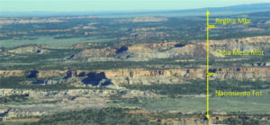
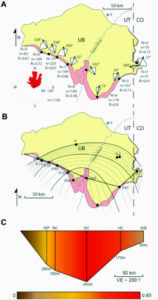 The Colton Fm. in the Uinta Basin, Utah is a Paleocene-Eocene boundary succession, and where it is exposed in outcrop along the southern margin of the Uinta basin it is a lobate wedge of dominantly fluvial deposits. The channel-fills of this paleoriver system are composed by sedimentary structures that suggest deposition during Froude-supercritical flow conditions. Abundant continental bioturbation and occasional preservation of pedogenically modified fine grained deposits in channel-fills suggest long periods of channel abandonment between depositional events. In the interpreted depositional axis of the system, near the present-day Green River, laterally and vertically amalgamated multistory channel deposits that are greater than 30 m thick are abundant suggesting frequent channel avulsion. These observations are consistent with a river system with flashy hydrology. Punctuated greenhouse climate change events at the Paleocene-Eocene boundary likely influenced the regional hydrology. Continuous exposures of the uppermost Paleocene to Early Eocene Colton Fm. in the Roan Cliffs along the southern margin of the Uinta Basin allow basin-scale analysis of changes in fluvial architecture. The package has highest gross thickness, sand content, and maximum channel dimensions in the interpreted axis of the system, near the present-day Green River. The gross thickness of fluvial deposits, sand content, and channel dimensions all decrease away from the interpreted axis of the system, and well-developed paleosols are common in the floodplain deposits of the system in the basin margins. Paleocurrents in the lower part of the Colton Fm. are radially distributive and statistically project to an apex approximately 150 km south of the Uinta Basin. This radially distributive wedge of fluvial deposits is interpreted as a large fluvial fan system that occupied the entire southern margin of the Uinta Basin. Changes in fluvial architecture through time in the Colton Fm. are consistent with a prograding (lower to middle 20 part of the Colton Fm.) and then backstepping (middle to upper part of the Colton Fm.) fluvial fan system.
*Stratigraphic complexity in fluvial fans: Lower Eocene Green River Formation, Uinta Basin, USA
Jianqiao Wang and Piret Plink-Bjorklund
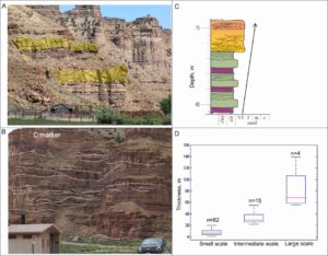 In this study, measured outcrop sections and geolocated photomosaics are integrated with areal mapping of channel dimensions, degree of amalgamation, calculations of channel-to-floodplain ratios, and sedimentary facies variability to study and quantify the channel and floodplain deposits in the Sunnyside Delta Interval of the Lower Eocene Green River Formation in the Uinta Basin, Utah. Vertically, sand content and bed thickness increase, due to an increase in the channel to floodplain ratio, channel size, and the degree of channel amalgamation. Laterally, the channel to floodplain ratio, channel size, the degree of channel amalgamation, and the sand content in channel facies decrease in the paleo-downstream direction. Such vertical and lateral transitions identify the Sunnyside Delta Interval as a fluvial fan (or distributive fluvial system). However, the vertical and lateral transitions occur at multiple spatial scales, demonstrating considerable stratigraphic complexity as compared to the existing facies and architectural models suggested for fluvial megafans and distributive fluvial systems. The smallest-scale transitions are identified as avulsion-related packages that form the building blocks of the stratigraphy, whereas the intermediate- and largest-scale transitions are suggested to be related to lobe and whole fan progradation respectively. This documented complexity indicates the significance of self-organization in building fluvial fan stratigraphy, and demonstrates that changes in the degree of channel amalgamation or in channel-to-floodplain ratio are not linked to accommodation changes. On facies scale, an abundance of Froude supercritical flow and high deposition rate facies, in-channel mud deposits, and in-channel bioturbation and desiccation indicate deposition in rivers with highly variable discharge. Such discharge conditions suggest seasonally and inter-annually variable precipitation conditions in the US Western Interior in the Early Eocene.
*Paleogene fluvial fans in San Juan Basin
Kristi Zellman and Piret Plink-Bjorklund
*Discharge Variability and Fluvial Fan Formation
Mark hansford and Piret Plink-Bjorklund
 Testing the link between fluvial fan occurrence and hydroclimate by using Hartlet et al., 2010 fan database and modern river discharge data.
*Scaling relationships in modern fluvial fans
Mark Hansford, Julia Payne and Piret Plink-Bjorklund
 This study collects data on modern fluvial fan scaling relationships, such as between the fan size and channel size, downstream channel decrease rates, and channel and fans size and hydroclimate.
Deltas
Tide-dominated deltas – a review
Michael Genecov and Piret Plink-Bjorklund
This study explores what we know about tide-dominated or strongly tide-influenced deltas from the ancient record. Do we have a consensus on what are the characteristic sedimentary facies and depositional sub-environments? How do the sedimentary features interpreted from the ancient record agree or disagree with data from modern tide-dominated deltas? What are the key similarities and differences?
Shallow-water deltaic clinoforms and process regime
Piret Plink-Björklund
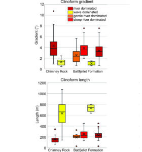 Utilizing two outcrop datasets with dip-direction exposures of shallow-water (tends of meters) deltaic clinoforms this paper quantifies sedimentary facies proportions and clinoform lengths and gradients, and links process regimes to delta clinoform dimensions. Both datasets are from foreland basins, the Cretaceous Chimney Rock Sandstone of the Rock Springs Formation from the US Western Interior, and the Eocene Brogniartfjellet Clinoform Complex 8 of the Battfjellet Formation from the Central Basin of Spitsbergen. Sedimentary facies indicate presence of both river- and wave-dominated clinothems in each dataset. Facies distribution infers that river-dominated clinothem progradation was primarily driven by deposition from weak hyperpycnal flow turbidity currents across the clinoforms, and minor slumps. Wave-dominated clinothems were constructed by wave processes rather than alongshore currents, and are also progradational subaerial clinoforms, with one exception, where the formation of a compound subaqueous clinoform set indicates erosion and sediment bypass above the wave base. Clinoform dimension analyses show that although of similar sediment caliber, river-dominated clinoforms in both datasets are on average 3-4 times steeper and 3-4 times shorter than the wave-dominated clinoforms, with mean gradients of ca 4 degrees and ca 1 degree respectively, and mean lengths of 152-230 m and 635-762 m. These results require corroboration from additional datasets, but do suggest that river- and wave-dominated delta clinoforms are likely to have distinct lengths and gradients for given clinoform heights. Clinoform shape can thus be a method for differentiating ancient river- vs wave-dominated deltaic clinoforms, in addition to their sedimentary facies, biogenic features and sandstone maturity, and helpful when incorporated into reservoir models. (Plink-Bjorklund, submitted. Basin Research Special Volume on Clinoforms)
Deepwater slopes and fans
*Froude supercritical flow bedforms in deepwater slope channels? Field examples in conglomerates, sandstones and fine-grained deposits
Kenya Ono and Piret Plink-Bjorklund
Active margin continental slope outcrops from the Eocene Juncal Formation, the Eocene La Jolla Group and the Miocene Capistrano Formation display sedimentary structures and depositional geometries that suggest deposition from Froude supercritical flow, based on comparison to strata produced by flume experiments. These deposits range from boulder-size soft clasts and cobble-size hard clasts to silt and mud, and display long wavelength and low-amplitude convex-up and concave-up geometries that range from centimetre to hundreds of metres scale, low-angle foresets and backsets, and common internal and bounding erosion surfaces from centimetres to tens of metres in depth. In places, planar laminations, structureless beds and normally graded beds are laterally or vertically associated with such structures. In other places, consistent backsets or deep and steep-sided scours occur. This study aimed to discuss the origin of the observed bedforms, contributed to recognition of supercritical flow deposits on continental slopes and expanded the outcrop examples of supercritical flow deposits to silt and mud. This work implies that the erosive and powerful Froude supercritical flow turbidity currents may have a substantial impact on erosional and depositional dynamics on deepwater slopes, especially on active margins due to the steep gradients and high
sediment supply. (Ono and Plink-Bjorklund, 2018)
*Froude supercritical flow channels in submarine canyon complexes, La Jolla Group, southern California
Kenya Ono and Piret Plink-Bjorklund
This paper documents an outcrop example of slope channel complexes from the La Jolla Group of the southern Californian Eocene forearc basin. This dataset demonstrates that the three slope channel complexes consist of channels 50-840 m wide and 5-100 m deep that display a relatively low aspect ratio, exhibiting an amalgamated and avulsive stacking pattern. Individual channels have a variety of heterolithic to sandstone and conglomerate fills, and all channel fills are dominated by Froude supercritical flow deposits. The transition of three channel complexes is considered to be related to the continental slope progradation on the upper slope. The potential progradational channel complexes demonstrate that highly channelized upper slope environment and the considerably lower slope progradation rate may be distinct characters of the active margins.
*OUTCROP EXAMPLE OF A CHANNELIZED SLOPE FAN, EOCENE JUNCAL FORMATION: ARCHITECTURE AND FROUDE SUPERCRITICAL FLOW CHANNEL FILL DYNAMICS
Kenya Ono and Piret Plink-Bjorklund
This paper documents an outcrop example of a channelized slope fan complex from the Juncal Formation of the southern Californian Eocene forearc basin. This dataset demonstrates that the slope fan consists of channels 360-860 m wide and 25-60 m deep that display a relatively high aspect ratio. The majority of the fan volume is formed by avulsive channel complexes. Individual channels have sandy to heterolithic, or just heterolithic, fills. Some channels are vertically stacked and composed of sandstone fills. All channel fills are dominated by Froude supercritical flow facies and geometries, and indicate frequent erosion and sediment bypass that alternated with rapid local deposition.
*Supercritical flow signatures and erosional features in Juncal Fm basin floor fans
Dessy W Sapardina and Piret Plink-Bjorklund
This drone photography survey of the Middle Eocene Juncal Formation in in Alyson Canyon in Los Padres National Forest, Santa Barbara and in Ojala, California, was motivated by a previous RioMAR study of approximately coeval slope succession in the Frazier Park area. Previous studies interpreted the Alyson Canyon area as proximal depositional lobe complexes in a basin-floor fan (Thompson, 1987), and the Ojala area along Highway 33 as outer-fan setting of depositional lobes (Obligado, 2003). In the Alyson Canyon area the facies are sandstone dominated and the sandstone facies occur as amalgamated, erosionally bound lenticular deposits. Only minor thinner-bedded and more tabular facies occur at the base of the outcrop. Sedimentary facies are dominated by scour and fill structures with upward flattening laminae, low-angle convex-up structures and backsets. The Ojai outcrops are also sandstone prone but the small size of the outcrop does not allow to observe larger bounding erosion surfaces. A few m to dm scale erosional scours are common and scour and fill structures and backsets are common sedimentary structures. In the Ojala area a proportion of heterolithic facies is larger and some heterolithic facies have a tabular architecture suggesting deposition in sheets or lobes, whereas sandstone-prone facies occur as erosionally bound lenticular deposits. Scour and fill structures and backsets are common sedimentary structures. Comparison to Froude supercritical flow experimentally produced data suggest that Froude supercritical flow deposits are common in the Juncal Formation basin floor fans. The erosion surfaces and the association of sandstone prone facies with the erosionally bound deposits suggest that the proportion of channelized deposits is high, and present even in outer-fan setting.
Paleogene climate
Paleogene hydroclimate
Piret Plink-Bjorklund and Lelland Sprangler
In hundreds of years from now, and with unabated emissions, a total of 5000 Pg carbon is estimated to enter the atmosphere, causing CO2 concentrations to rise to approximately 2000 ppmv and global temperatures to warm by more than 8°C (Zeebe and Zachos 2013). A carbon release of this magnitude has been unprecedented during the past 53-56 Myr since the PETM and the Early Eocene Climatic Optimum (EECO) (Fig. 1) (Zachos et al. 2008). This has made the PETM the best studied and best known past global warming event (e.g. Anagnostou et al. 2016), despite the large uncertainties in CO2 concentrations (Fig. 1) (Zeebe and Zachos 2013) and differences with the modern carbon release rate (Zeebe et al. 2016). The PETM is not an isolated occurrence, but rather an extreme event during the generally warm early Paleogene, a period of rising and then falling temperatures, with culmination during the EECO (Fig. 1, Table 1). Compared to even earlier warm periods, such as the Cretaceous, Jurassic or Triassic, the paleogeography during the early Paleogene is reasonably well constrained and most like the modern configuration of plates. There is also a relative wealth of climate proxy data compared to the older warming events. This study aims to compile data on Paleocene and early Eocene climate conditions to study long-term trends and short-term variability, with the focus on hydroclimate and precipitation patterns.
Global climate types of the Paleocene-Eocene Thermal Maximum
Leland Sprangler and Piret Plink-Bjorklund
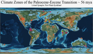 This study is part of the above effort and focuses specifically on the global climate distribution during the PETM.
Sedimentological and geochemical record of paleogene climate in the San Juan Basin
Kristi Zellman, Piret Plink-Bjorklund and Henry Fricke
Foreland basins
Foreland basin systems with a focus on the forebulge and backbulge depocenter – a review
Andrew Heger, Donna Anderson and Piret Plink-Bjorklund
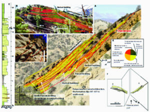
Far-field stresses as a key control on evolution of the Devonian Baltic Basin
Piret Plink-Bjorklund and Lennart Bjorklund
This study links far field tectonic events and crustal heterogeneity to the evolution of the Devonian Baltic Basin – a backbulge depocenter.
Signal propagation
Signal propagation framework for sedimentary systems
Haipeng Li and Piret Plink-Bjorklund
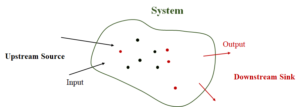 In essence, the propagation of signals of sediment and water discharge conditions is a special case of sediment transport problem. Instead of focusing on the local details of hydrodynamics, we devote our attention to the global picture of how a specific change in water and sediment discharge conditions will be transported, preserved, modified, and identified. Although a change in sediment and water discharge condition is called a signal, it does suggest a single cause. A signal can be characterized from different aspects, such as the rate of change from the base condition, its duration, magnitude, etc. Everything related to signal propagation, preservation, and identification makes sense if and only if we specify the upstream source, the system or channel, and the downstream sink. Factors that control signal propagation include the signal itself, the base condition, and the system. Two types of noises are identified, additive and multiplicative. They have impacts on signal propagation, preservation, and identification. Signal identification requires using both microscopic and macroscopic attributes, and it also depends on the autogenic processes that modify the signal. Upon identification, a multiple-hypotheses working method is needed for better interpretation of the signal.